About Us
Olkalou Constituency
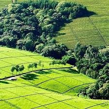
Limuru is a town in Central Kenya. Limuru is a name of a parliamentary constituency and an administrative sub-county. The constituency is divided into five administrative wards.The town is a town located on the eastern edge of the Great Rift Valley from Nairobi. Limuru is a cold place .It derived its name from the Maasai word “llmur’ .It was named so because it is the indigenous home to many donkeys. You will not miss one or two donkeys in every corner. It is used as a means of transport especially on luggages.The population of Limuru as per year 2019 census population was 159,314 and the registered voters in the 2017 voters register was 87,258.
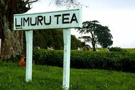
2. It has an incredible amount of colonial history, much of which contributed to it been one of the largest producers of tea in East Africa.
3. Limuru is also known for the famous Bata shoe factory. Located at the centre of the Town. Produces high quality shoes, handbags, school and travelling bags .It has given work to many of the residents of the constituency.
4. Browns Cheese a cheese farm located at Kamonde enroute to Limuru Girls,produces more varities of cheese than any cheese makers in Africa.
5. The town also has a railway station which is been revived.The famous “ Buxton” tunnel is the oldest and and second longest tunnel in Kenya.The tunnel is estimated to be 1.7 km long.
6. The constituency is also home of the best high schools in Kenya;Loreto Girls High school and Limuru Girls school.
7. St Paul’s Universtiy Limuru is the main institution of high learning located in the outskirts of the town.Apparenlty Limuru being one of the coldest regions in Kenya,there is no river in Limuru.The agricultural activities are fuelled by natural rainfall and man-made water reserves for small scale farmers.
Access NG-CDF Information on your Mobile


County Assembly Wards in Olkalou Constituency:
Limuru Central Ward
- County Assembly Ward No.:
- County Assembly Ward Name: Limuru Central
- County Assembly Ward Population (Approx.):
- County Assembly Ward Area In Sq. Km (Approx.):
- County Assembly Ward Description: comprises part of
Limuru East Ward
- County Assembly Ward No.:
- County Assembly Ward Name: Limuru East
- County Assembly Ward Population (Approx.):
- County Assembly Ward Area In Sq. Km (Approx.):
- County Assembly Ward Description: comprises part of
Ngecha-Tigoni Ward
- County Assembly Ward No.:
- County Assembly Ward Name: Ngecha-Tigoni
- County Assembly Ward Population (Approx.):
- County Assembly Ward Area In Sq. Km (Approx.):
- County Assembly Ward Description: comprises part of
Ndeiya Ward
- County Assembly Ward No.:
- County Assembly Ward Name: Ndeiya
- County Assembly Ward Population (Approx.):
- County Assembly Ward Area In Sq. Km (Approx.):
- County Assembly Ward Description: comprises part of
Bibirioni Ward
- County Assembly Ward No.:
- County Assembly Ward Name: Bibirioni
- County Assembly Ward Population (Approx.):
- County Assembly Ward Area In Sq. Km (Approx.):
- County Assembly Ward Description: comprises part of